

1948 to 2016 Comparison
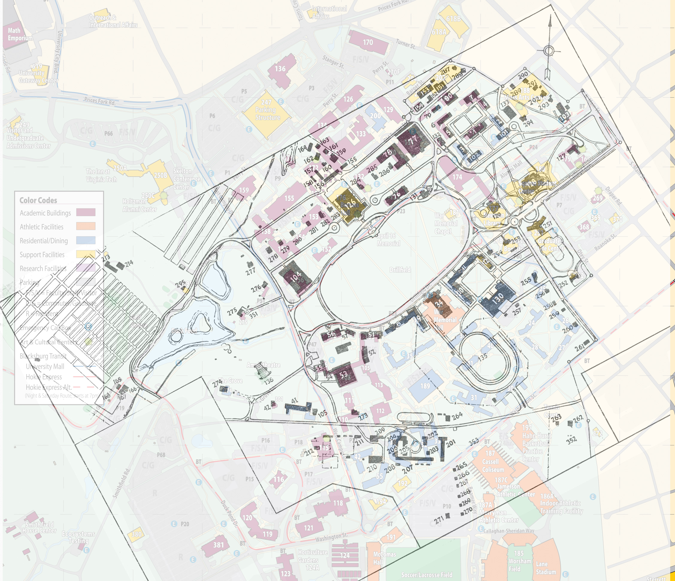
This overlay of the 1948 map on the 2016 campus map shows how much the campus has changed and how much has stayed the same. The buildings on the 1948 map by number are listed with the present equivalent building, location, or name.
1-12 Dormitories
1 Lane Hall
2 Barrack #2 -- Rasche Hall location (now Pearson Hall)
3 Barrack #3 -- Brodie Hall location (now New Cadet Hall)
4 Barrack #4 -- Shanks Hall
5 Barrack #5 -- Major Williams Hall
6 Barrack #6 -- Major Williams Hall
7 Barrack #7 -- Thomas Hall location
8 Campbell Hall, Main
9 Campbell Hall, East
10 Eggleston Hall, West
11 Eggleston Hall, Main
12 Eggleston Hall, East
34 War Memorial Hall (Gym)
41-42 Girls’ Dormitories
41 Hillcrest Hall
42 Institute for Society, Culture and Environment
51 Agricultural Building -- Hutcheson Hall
52 Natural Science Building -- Smyth Hall
53 Agricultural Engineering Building -- Seitz Hall
54 Home Economics Building -- Agnew Hall
55 Dairy Building -- Saunders Hall
56 Agricultural Hall -- Price Hall
57 Extension Division Offices -- Sandy Hall
76 Patton Hall
77 McBryde Building (original) -- McBryde Hall
78 Mineral Industries Building -- Holden Hall
79 Engineering Laboratory -- Femoyer Hall location
80 Mechanical Engineering Laboratory -- Art and Design Learning Center
101 First Academic Building -- Rasche Hall location (now Pearson Hall)
102 Second Academic Building -- Brodie Hall location (now New Cadet Hall)
103 Commerce Hall -- now parking lot for Moss Center
104 Davidson Hall
105 Home Management House -- demolished
126 Burruss Hall (Auditorium)
127 Infirmary -- Henderson Hall
128 Student Activities Building -- Squires Student Center
129 Library (original) -- Newman Library
130 Dining Hall -- Owens Hall
131 Veterans’ Guidance Building (demolished)
132 Military Building -- Liberal Arts Building
133 Military Laboratory -- Shultz Hall location (now part of Moss Arts Center)
135 Miles Stadium -- location of Lee, Pritchard, O’Shaughnessy, Payne, Peddrew-Yates, and New Residence Halls East
136 Garden Theatre -- Amphitheater
151 Power Plant
152 Monogram Shop -- demolished
153 Utilities Building -- Military Building/Laundry
154 Plumbing Shop -- Old Security Building
155-164 Storage Lot Buildings -- location of Burchard, Cowgill, and Hancock Halls
165-168 Sewerage Disposal Plant -- now Oak Lane Overflow Parking Lot
The entire complex below was in the area now occupied by Ambler Johnston, Cochran, Harper, Engel, and Wallace Halls
201 Animal Husbandry Barn
202-203 Experimental Dairy Barns
204-208 Dairy Barns
209 Farm Machinery Barn
210 Horse Barn
211 Stock Judging Pavilion
212 Poultry Plant Laboratory
213-214 Experiment Barns -- located on the Golf Course adjacent to the Tobacco Barn
251 Faculty Center -- Graduate Life Center at Donaldson Brown
252 University Club
253 Extension Division Apartments -- University Bookstore location
254 Residence, some maps show it as Magill House
255-261 Faculty Residences -- location of Vawter and Barringer Halls
262 Veterans’ Social Center -- demolished
263 Faculty Residence -- demolished
264-271 Farm Residences -- location of Beamer Way and Coliseum parking lot
273 Faculty Residence -- demolished, on part of Engel parking lot
274 Faculty Residence -- The “Grove” President’s House
276 Faculty Residence -- Wright House
277 Faculty Residence -- demolished
278-286 Faculty Residences on “Faculty Row” -- location of Hahn Hall South, Robeson, Pamplin, and Norris Halls
287-288 Faculty Residences -- Power Plant coal pile
289-293 Faculty Residences -- demolished, location of Shultz Hall, now Moss Arts Center
294 Faculty Residence -- demolished, was at one time Commandant’s House
295 Farm Residence -- Golf Course Clubhouse
275 Veterans’ Social Center -- Solitude
351 Trailer Camp #1 -- “Vetsville”
352 Trailer Camp #2 -- “Hurricane Hill”