

Campus Streets
One hundred years ago, the streets of downtown Blacksburg were not much different from the streets of today. Main Street ran from the south to the north, taking a jog to the right at College Avenue to climb the hill that skirted the original Preston and Olin buildings and those that had been added by the growing college. It continued for several blocks before reaching the edge of town.
The streets of the campus have changed considerably though, with many streets being eliminated as the campus grew.
In the mid-teens of the last century, the Upper Quad had already been established with the construction of Barracks No. 1 (now Lane Hall), Barracks 2-5, the First and Second Academic Buildings, Science Hall, and the YMCA. The area was bounded on the east by faculty residences and the dining hall, which fronted on Whisner Street. This street was intersected on the south with Faculty Street, which ran east to Main Street and beyond, and ended at Turner Street, which ran west from Main Street, took the same bend it takes today, and continued north to eventually become Peppers Ferry Road.
Running to the west off of Turner Street were Stanger Street and Barger Street (remnants of which exist today). Barger Street ran along the northern edge of campus, serving houses along both sides of the street. Stanger Street ran behind Faculty Row to the vicinity of Pamplin, where it turned south. Faculty Row ran on what is today the sidewalk from the Liberal Arts Building, passing in front of McBryde Hall and through the Burruss tunnel, in front of Pamplin Hall and behind Davidson Hall, ending at today's West Campus Drive. To the south, College Avenue ran west into the campus, serving Gibboney Field, the field house, and Agricultural Hall (now Price Hall).
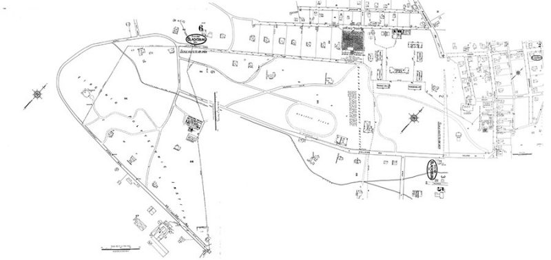
In the 1920s, a street system was pretty well established, starting from the Alumni Gate entrance to campus. The First 100 Years reports on the completion of the gateway. “During the session of 1913-14, an alumni gate opening onto the campus at a point closely adjacent to the present intersection of College Avenue with Main Street was completed. A curving driveway was constructed from this gateway, passing north of Henderson hall and up the hill until it passed in front of both academic buildings (now the site of Rasche and Brodie). After passing these two buildings, it curved sharply to the north and then branched into a “Y” with one branch passing by the YMCA (present Student Personnel Building [now the Liberal Arts Building]) and the other branch curving westward down Faculty Row. This drive was joined in front of the second Academic Building by a branch road which meandered southward by the library and the field house. Another branch road joined it in front of McBryde Hall and led to the Administration Building, which stood on a site about halfway between present Patton Hall and the Memorial Chapel. This alumni gateway provided the main entrance to the campus until it was removed in 1936 in order to widen Main Street.”

Clay Street was at one time a main entrance to campus. It followed the same route as today from Main Street and extended to the west, becoming Park Row. From the present end of the street, it angled across the campus, crossing the area now covered with the tennis courts on Washington Street. From there it continued to run behind today’s Hillcrest Hall, continuing on today’s Grove Lane to today’s Duck Pond Lane, which it followed to loop around the end of the Duck Pond. It became Rural Avenue where the loop turned east. This road continued to loop and intersected with Faculty Row, at which point a road continued south, intersected with College Avenue behind Agricultural Hall, and connected back with Park Row in the vicinity of today’s Engle Hall.
The “agricultural” side of campus grew to the southwest of the “main” campus around the upper quad. Agricultural Hall anchored the area, with greenhouses and other buildings clustered around it. On the hill above and to the south were the dairy barns and other buildings, located in the area now occupied by buildings from Ambler Johnston west to Hillcrest. A long-time campus landmark, the water tower, was also located in this area.
The major road that would define the campus from that point on was constructed in the early 1930s. The 1934 Bugle in its “Campus Views” section mentioned
“THE NEW CAMPUS ROADWAY . . . inclosing the drill field in a perfect oval. It serves as an obvious connecting link between the present growing V. P. I. and the future greater V. P. I.”
The open area in the center of campus was already well established. It had been used as a parade ground and Gibbony Field (later Miles Field) and the field house set the area for athletic events. In 1926, the War Memorial Gymnasium was constructed on the south side of campus in the vicinity of Miles Field. That playing field was replaced with Miles Stadium behind and to the south of the new gymnasium. Agricultural Hall and the Extension Building, Davidson Hall, Patton Hall, and Barracks No. 8 (now Cambell Hall) established boundaries around the open area. The new road on the north side of the Drill Field started at the road to the adminstration building and ran west toward Davidson Hall, where it turned south to connect with existing College Avenue in front of Agricultural Hall. The loop was completed with a new road from College Avenue north to the administration building.
The campus road and street pattern remained relatively stable through the 1930s and 1940s, mainly due to the Depression and the focus on (and shortages due to) World War II. Changes started post-war as the campus expanded along with the town. The construction of the Meat Processing Laboratory (now Food Science and Technology Laboratory) on the southwest edge of campus, along with greenhouses adjacent to the east, extended a roadway from the loop around the Duck Pond to serve those two buildings. This established the path for the future extention of Washington Street. That loop is the path of the current Duck Pond Drive, which at that time extended on to the south then turned east on the path of today’s Southgate Drive, passing under the Norfolk & Western Railway track and ending at Christiansburg Road (now Airport Road), the main road into town from the south.
Map of Virginia Tech campus in 1960

The biggest change since the establishment of the Drillfield oval came in late 1946 when the construction of a World War II memorial was proposed. The structure was to overlook the Drillfield from the northeast end. “A 200-foot mall lined with trees will lead to it from the state highway. This thoroughfare will be the main entrance to the campus.” according to the report in The Virginia Tech on November 1, 1946. There was opposition to the construction of this new road since it would cut through a grove of trees in the area between the Upper Quad and the Student Activities Building (Squires). This plan was added to a master campus building plan that was developed by a building and grounds committee and approved by the Board of Visitors in the spring of 1950. The Mall was completed in the next year and showed on the 1952 campus map.
In the mid-1950s the number of barns and sheds around Hillcrest was reduced and the road in front of the Meat Processing Lab was extended to the east on the track of what would eventually be Stadium Road. At what is the current intersection with West Campus Drive, another road was extended to pass Miles Stadium and connect with the at-that-time end of Washington Street at Kent Street. Spring Road (now Beamer Way) connected Washinton Street with the road from the greenhouses as it continued south to serve the agricultural part of the campus.
Kent Street at that time ran northwest to end in a roundabout at College Avenue, running adjacent to a row of houses on the west side with the Faculty Center and pond (now the Graduate Life Center at Donaldson Brown) and the University Club on the east side (now the site of the Creativity and Innovation District residence hall). Otey Street ran on the east side of the Faculty Center, ending at College Avenue in front of Squires as it does today.
The 1960 campus map showed a number of changes to the campus streets. Washington Street was in place from Kent Street to the west past the stadium, passing behind the complex of barns adjacent to the Biochemistry building (now Engel Hall) and meeting up with the existing road by the greenhouses. A proposed new road was shown running from today’s Grove Lane south to connect with Washington Street. A year later Greenhouse Road was in place and Park Row was severed, with only a short stretch remaining in front of the barns. With the construction of a new dairy center in 1962, the remaining barns on the original site were removed, leaving a parking lot where today’s Smith Career Center stands today. The new dairy center (demolished in 2016 to make way for a runway extension and clear zone) resulted in an extension of Southgate Drive in the approximate location of today’s intersection of Duck Pond Drive and Southgate. Another road was extended in the 1950s south on the location of today’s Tech Center Drive to serve the poultry unit (chicken coops and lab buildings), leading to the area being called “Chicken Hill” to this day.
On the other side of campus, Faculty Row was severed in the middle with the construction of Burruss Hall in 1936. The two streets remained to serve the dwindling number of faculty houses, which were gradually replaced by the original McBryde Hall, Holden Hall, Williams Hall, and Commerce Hall (now Pamplin Hall). It wasn’t until 1961 that the last vestiges of this major thoroughfare were eradicated from the campus map. Another change took place in front of Burruss Hall in 1953, when the split roadway was eliminated. Up to that point, the road divided about where the sidewalk between Burruss and Patton is located and rejoined about where the sidewalk between Burruss and Williams is located. One section of the road ran across the current plaza about where the flagpoles are located today. The other section passed on the Drillfield side of the “reviewing stand,” where the April 16 Memorial is located today.
Parallel to Faculty Row to the north was a street referred to as Stanger Street on some maps and Turner Street on others. It ran from Pepper’s Ferry Road (later Prices Fork Road) adjacent to the power house. This street passed behind McBryde, Holden, and Burruss and tied in with the road around the Duck Ponds. It provided access to the facilities area and the “temporary” buildings that were erected after WWII. The street was truncated in front of Randolph Hall when Cowgill Hall was constructed and the plaza built between that building and Burruss Hall. The other section was replaced by the parking lot constructed between Derring Hall (which replaced the temporary buildings) and Pamplin and Robeson halls.
Also in the area were additional streets running parallel with Stanger/Turner -- Barger Street and Petry Street (later Perry Street). The 1928 Sanborn map of Blacksburg shows houses along these streets for about two blocks. West of there, later campus maps show orchards, fields, and barns in the area between Burruss and the ponds and Price’s Fork Road. Part of that area was developed as a turf grass project in 1954, the result being a 9-hole golf course. Over time, the rest of the area changed to a gravel parking area for commuter students, then a paved parking lot, and recently a parking garage and engineering building sprouted where peach and apple trees grew. The golf course was expanded to 18 holes, then the front 9 holes were replaced with The Inn at Virginia Tech and Holtzman Alumni Center.
By the late ’60s, the campus streets were pretty well established with only minor changes since then, mainly due to building construction. While not a campus road, the completion of the U.S. 460 bypass around Blacksburg (from S. Main Street to N. Main Street) had an impact on the town and campus. The road to the dairy barns to the south of campus was extended to an at-grade intersection with the four-lane highway. This provided a more direct route to the growing athletic facilities on the south side of campus, Lane Stadium, the Coliseum, and the baseball field.
In 1973, in anticipation of the construction of the new bookstore, Kent Street was shifted west from the vicinity of Vawter Hall to make a direct connection with the Drillfield at Eggleston Hall. The original section of the street became parking and dead-end access as a service drive for Donaldson Brown. Several years later when the addition to Newman Library was constructed, College Avenue between Otey Street and the Drillfield was closed and converted to a pedestrian plaza. In the late ’70s as part of the project to widen Prices Fork Road to four lanes, Greenhouse Road was shifted slightly to create a four-way intersection with the widened road and Woodland Drive.
Other minor changes were the renaming of Greenhouse Road to West Campus Drive in 1989 and renaming Spring Road to Beamer Way in 2015. The Board of Visitors renamed the street between Southgate Drive and Washington Street to honor football coach Frank Beamer and his wife Cheryl to recognize the contributions of both made on and off the field (see https://vtnews.vt.edu/articles/2015/08/080615-bov-beamerway.html).
The proposed new Southgate interchange bridge with the Virginia Tech name and shield as seen from U.S. 460.

The most recent change to the campus road system started in 2016 with the construction of a diverging diamond interchange on U.S. 460 to replace the at-grade intersection with Southgate Drive. The work is concurrent with the extension of the runway at the Virginia Tech Montgomery Executive Airport. The interchange and new road, which resulted in a new entrance to campus and to the Corporate Research Center, opened in December 2017. The Dairy Center, which was in the safety zone at the end of the extended runway, was relocated to Kentland, clearing the route for the new road. Southgate now ties in with the existing road at a roundabout at the Duck Pond Drive intersection. Another roundabout is at the intersection of the new road to the Corporate Research Center, made necessary by the removal of Tech Center Drive by the runway extension (see https://vtnews.vt.edu/articles/2015/03/031815-vpa-southgateproject.html).